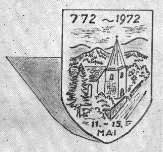
Shield created for the 1200-year festival of Heckenbach, showing the old chapel. |
Village(s) of Heckenbach
Location and History
The hilly backland west of the Rhine and north of the vine-covered slopes of the Mosel River in Germany, and to the east of Luxembourg and Belgium, is known as the Eifel. To the north along the Rhine is the former capital, Bonn. The average elevation of the Eifel is about 2000 feet. The area was volcanic in ancient times, and numerous hot springs remain. The world's tallest geyser is located near Andernach. The area contained numerous deposits of high-quality iron ore but the soil tended to be poor. There are numerous small lakes, some being ancient volcanic craters. The weather is moderate, with monthly average temperatures ranging from 36 to 64 degrees F. The Ahr River cuts through here and, flowing to the Rhine, divides the area into two parts. The northwestern part is in the state of Nordrhein-Westfalen, and is known as the Schnee Eifel. It's a rugged area of deep woods. The southeastern section belongs to state of Rhineland-Pfalz.
The area called the Heckenbach Ländchen consists of Heckenbach and a few neighboring villages. The village of Heckenbach is divided into two parts, Nieder- and Oberheckenbach (lower and upper), the latter being 51 meters higher in elevation. Their centers are approximately 1000 meters apart.
The Eifel was well-known to the Romans. They built a stone road nearby, Die Römerstrasse. They frequented the hot mineral springs, built villas, mined for iron and stone, and traded the products all over the known world. Some traces of their presence are still visible. The oldest known artifact is a Roman coin dated 41 B.C., the time of Julius Caesar, found at Lommersdorf. Also found were coffins, pottery, and weapons. A few Roman place-names are still in use. During this time magic and superstition played a big part in daily life. Spirits were thought to roam the countryside. This belief system tended to keep people in towns and cities. In the 7th century the Romans and their Celtic subjects were evicted by the Franks. Their king Charlemagne, who also conquered most of France, Italy, and the low countries, ruled from Aachen and brought Catholicism to the area.
There were few roads, so people found their way by following rivers and streams, and the deeply-cut valleys divided the terrain. On a southeastern tributary of the Ahr River was a Frankish encampment called Adagana, or Ad Hagana in Latin; that is, On The Hagana. The name of the stream was Germanicized to Hagenbach. In the year 772 the name was first written as "Heckenbach." Hage and Hecke both mean hedge/brush/grove/thicket. Bach means creek/brook. "Brush Creek" pretty well describes the landscape. The creek flows into the Staffelbach, which empties into the Ahr at the town of Brück.
In 772 Bertrudis and her son Wannig presented their property in Adagana to the monastery in Kesseling. The Heckenbach area belonged throughout the Frankish rule to the Ahr province. In a sense it does again, being in the present-day administrative district of Ahrweiler, a city on the Ahr about 35 km south of Bonn. Bertrudis was probably a close member of Charlemagne's family.
There are bits of information recorded through the years but the area had little strategic importance. After 1200, that province fell into 15 feudal estates. The fief of Heckenbach, along with two others, was owned by a noble family in Königsfeld (now called Niederzissen) for fifty years until that family died out. In the turbulent and complex German history, the little town was shuffled among various governing districts controlled by a succession of lords and counts. These changes of ownership were brought about by inheritance, royal decree, direct sale, war, or church dictum from Rome. For a time the Hapsburgs of Austria controlled the area. Then King Rudolph von Hapsburg presented the land to Gerhard I whose family controlled it for 100 years. Dietrich von Schönberg gained possession in 1371. In 1397, the town was divided, Oberheckenbach going to Friedrich von der Tomburg and the other portion to his brother, Bernhard. In 1404 the area was pledged to Count Ruprecht von Virneberg. From 1430 to 1460 the proprietor was Sir Krafft von Saffenburg.
All during these centuries times were hard and life expectancy was low. The soil was poor, suitable only for grazing. Mining was hazardous. People commonly had many children, of whom few survived. Sometimes the records show two children of the same family with the same first name, because the first child died and its name was "reused."The 30 Years War (1618-1648) devastated Europe. The Eifel went
under French control from 1648 until 1762. In 1767, the
Bessenheim family of Counts received the holdings of Heckenbach (along
with Kassel, Watzel, Fronrath, Langhault, and Kohlhof.) The French
under Napoleon ruled again from 1794 until his defeat in 1814, when
Heckenbach was made a commune
under the mayor of Königsfeld. During
the 1800s taxes were high and there were famines, particularly in
1817, but forests and mines were exploited to provide material
for trade, and herding and some meager farming activity took place.
After
Napoleon the territory reverted to Prussia, but the
commune was retained until the World War II destruction.
Recent History of Heckenbach
In 1936, the Heckenbach Ländchen (5 villages) was selected as a Luftwaffenübungsplatz. That is, an air force training grounds for the Nazi military. There were protests, such as by the bishop of Trier, but all 650 inhabitants of the ländchen (99 from Oberheckenbach and 147 from Niederheckenbach among them) were evacuated by November 1938. They were paid for their losses of buildings, land, and crops, according to a formula, and resettled elsewhere.
The military then moved in and used the old half-timbered barns and houses for target practice. In the case of Oberheckenbach, every structure was destroyed except the old chapel, built in 1730. Niederheckenbach lost all its buildings but a portion of its church.
The bombing practice was soon completed by the Luftwaffe and while World War II raged elsewhere, it was quiet in the Heckenbach area. The land saw brief use as Herman Göring's personal hunting grounds. The bombs created a large crater outside of town which is used today as a reservoir.
After the war a resettlement took place. In 1950, 65 families came in from heavily damaged parts of Germany or from Sudetenland. The industrious settlers cleared land and planted crops. They also raised Corsican sheep, which Göring had introduced. Soon a handful of houses and an inn were built. The church was restored in 1958 and a school was opened. In 1960, the citizens reaffirmed the commune to include Beilstein, Blasweiler, Frankenau, Niederheckenbach, and Oberheckenbach, with a total population of 380.
In May 1972, the commune celebrated the 1200-year anniversary of the village's pledging with a 4-day festival. Besides the music and dancing, the community drafted a directive that recognized both the recent progress and the historic and scenic attributes of the area, and predicted that positive further development would occur.
Shield created for the 1200-year festival of Heckenbach, showing the old chapel. |
Today the area is a scenic recreation spot favored by motorcyclists and hikers. In October 2000 a network of historic footpaths (about 18 km) was dedicated, connecting the varied landscape of low streams and steep hills, juniper moor and thick forest.
Updated March 16, 2013.